PART 1: ASHEVILLE & APPALACHIA
On Tuesday, September 24th, rain began to fall across the Blue Ridge Mountains. A slow moving front had settled over the area, fed by tropical moisture from a storm that was working its way inland from the Gulf of Mexico. That day, the storm was 500 miles and 30 hours away from making landfall in Florida. By Wednesday, Potential Tropical Cyclone Nine became Hurricane Helene. As the storm barreled toward Florida, picking up speed in the warm waters of the gulf, it was clocking winds of 90 mph. Within 12 hours, it thundered into the coast of Perry, FL at 140 mph, making it a Category 4 hurricane.
Massive storm surges sent 10 ft waves of water across The Big Bend of Florida, destroying homes and businesses along the way. The unseasonably warm waters of the gulf gave Helene such speed, she made her way into Georgia carrying 100 mph wind gusts even as a downgraded tropical storm. Once Helene came onto land, she maintained a path 40-70 miles east of where the storm was predicted to travel, through Atlanta and into central Tennessee.
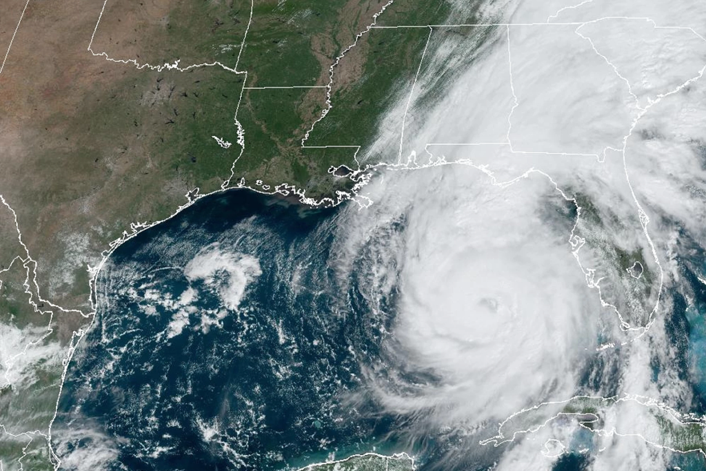
But Helene was unpredictable from the start, refusing to be underestimated or follow expectations. As the storm entered South Carolina, she abruptly turned to the northeast, toward the mountains of Western North Carolina, an area that had already received between 8 to 16 inches of rain over the past several days. As Helene descended into Appalachia, she brought high winds and at least 12 inches of additional rain, giving birth to the 1,000-year storm.
On September 26th, the National Weather Service issued the following message: “URGENT: This will be one of the most significant weather events to happen in the western portions of the area in the modern era. Record flooding is forecasted and has been compared to the floods of 1916 in the Asheville area.” But for many, it was simply too late.

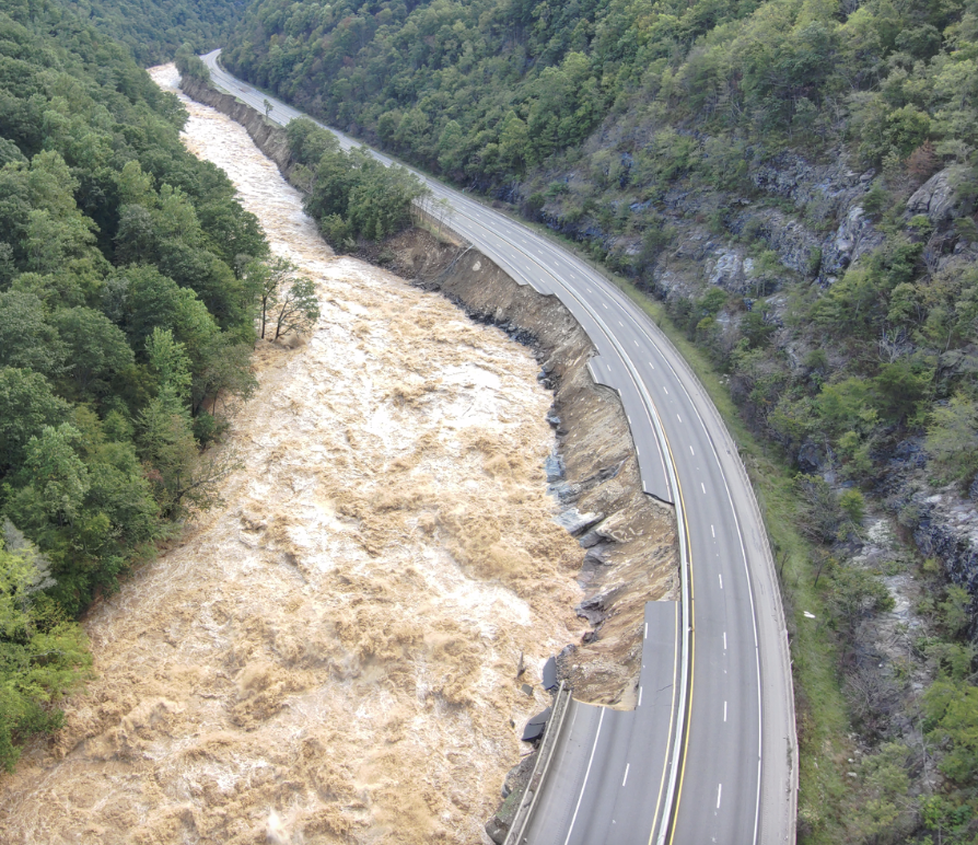
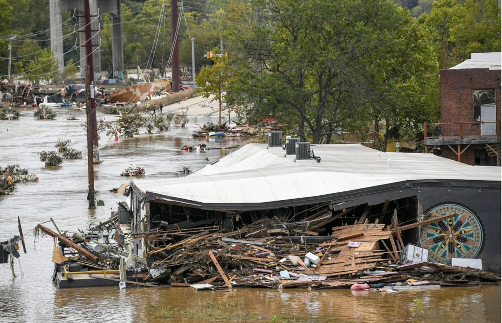
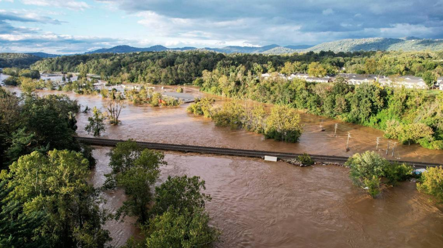
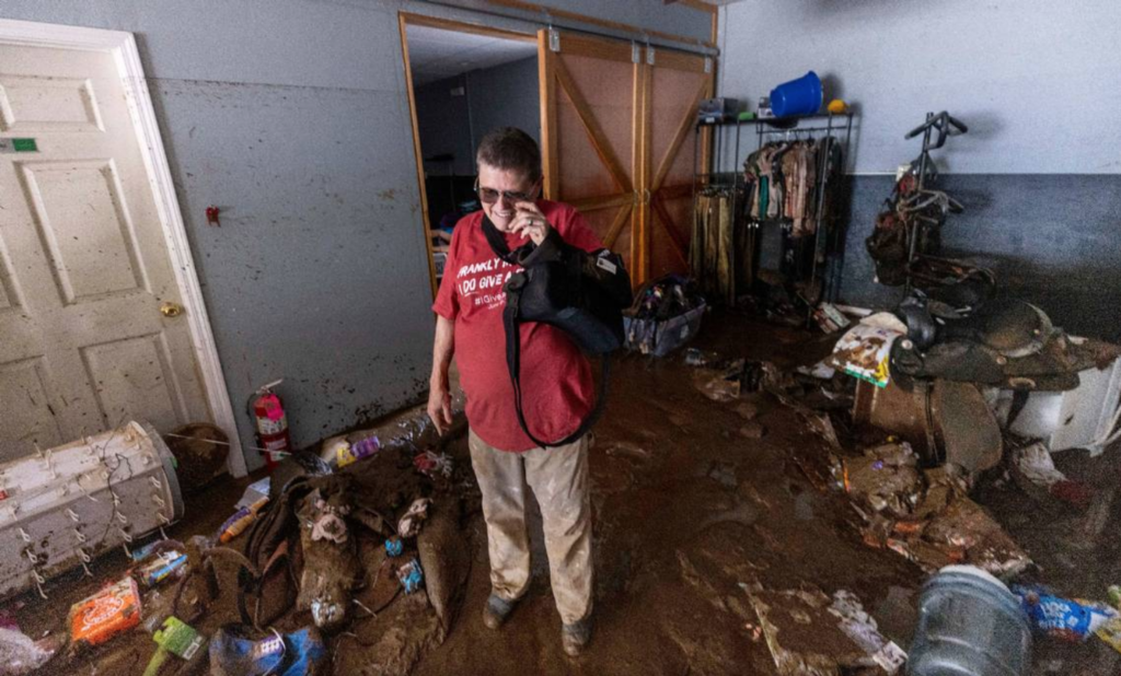
The aftermath has been referred to as “biblical devastation”, and several towns within the 25-county area have been completely erased from the landscape. The number of survivors is still unknown today, nearly a week after the storm, because accessibility is nearly impossible. Race for Life Rescue arrived on Monday, Sept. 30th, to evacuate animals and deliver hurricane relief supplies. The destruction is unprecedented, and the heartbreak felt for these communities, their people and the animals is immense. During a natural disaster, you often hear the phrase, ‘they lost everything’, and it’s without a doubt applicable to the residents of Asheville and the surrounding towns, but this event brought a level of violent destruction rarely experienced.
What made Helene such a catastrophic storm?…and will it happen again?
That’s one of the key questions on many people’s minds as the recovery from Helene continues in Western North Carolina, with more than 55 people confirmed dead and damage estimated to be in the tens of billions of dollars. Experts are offering insight to the contributing factors and warning of its reoccurrence. Here’s the role each element played in creating ‘the perfect storm’.
WARM WATER
Scientists have been eyeing warm waters in the North Atlantic and Gulf of Mexico warily for months. Warm water means more water vapor, and water vapor is one of the key ingredients in severe weather.
“Water vapor is weather fuel. It’s like you have this huge reservoir of anomalously large weather fuel and then you basically just need some mechanism to ignite that fuel,” said Gary Lackmann, the head of N.C. State University’s Marine, Earth and Atmospheric Sciences department.
As Helene made its way through the Gulf of Mexico last Wednesday and Thursday, it was passing over abnormally warm water. Climate change, it’s worth noting, has a major impact on ocean temperatures. About 90% of global warming takes place in oceans, according to NASA. And on Sept. 25th, the Gulf of Mexico’s sea surface temperature averaged 84.2 degrees between 1991 and 2020. This year, Helene encountered waters averaging nearly 86.7 degrees.
The warmer water ran deep as well, creating a high fuel content and rapidly intensified Helene in the hours before she made landfall, strengthening from a Category 1 to a Category 4 as the storm swiftly approached Florida.
PRECEDING PRECIPITATION
As Helene was working its way northward, Western North Carolina was already experiencing heavy rainfall. A low-pressure system before the storm stalled over the Tennessee Valley, effectively creating an atmospheric wall with severe weather on its eastern side.
Low pressure systems create strong southerly winds and lift air into the atmosphere, where water vapor is more likely to condense and become rainfall. In turn, those strong winds picked up vapor-laden air that was already in the Gulf of Mexico and carried it into Western North Carolina, where strong rains started falling about 36 hours before Helene even reached Florida.
“Even without Helene there would have been a significant rainfall and flooding event just due to the other weather system and setup and this really vapor-rich air,” Lackmann said.
With the added arrival of Helene, the combination was simply insurmountable.
GEOGRAPHY
The Blue Ridge Mountains played a bigger part than you might think. As winds out of the east or southeast run into the mountains, air is pushed upward. And as air goes upward, more of the water vapor within it comes out in the form of rainfall or, in winter, snow. In the case of Helene, that played a significant factor, said Chip Konrad, the director of NOAA’s Southeast Regional Climate Center. “There was more water vapor available to come in and then basically just being wrung out of the atmosphere at a very rapid rate as it’s being forced up against the Blue Ridge escarpment,” Konrad said in an interview.
SPEED
The jet stream also played a role when Helene came into the picture, helping the storm move swiftly northward through Florida, Georgia and South Carolina into Western North Carolina. At one point after making landfall, Lane said, Helene was moving 40 to 45 mph through the Southeast. Normally, storms have time to lose energy over land. This one didn’t.
THEN HELENE CAME ON THE SCENE
The region’s strongest rainfall came as Helene was passing west of the region, Lane said. The worst place to be when a hurricane is making landfall is the east side. “By far the worst impacts are going to be in that area from just east of the center out to about 100 to 200 miles,” Justin Lane, a meteorologist at the National Weather Service, said. And that’s exactly where Western North Carolina was.
But this wasn’t the first 1,000-year rainstorm in North Carolina this year. In mid-September, an unnamed slow-moving storm produced more than a foot of rainfall closer to the Atlantic coast. This storm inundated areas that had already been drenched by Tropical Storm Debby in August.
Atmospheric scientists and state climatologists believe it’s important for the public to understand the risk that extreme events may occur. That’s especially true as climate change alters the conditions that create and feed storms.
FORECASTING THE FUTURE
The problem with terms like 100-year event or 1,000-year event is that many people hear them and assume they mean another storm of that size shouldn’t occur for another 99 or 999 years. That’s a reasonable conclusion, but it’s incorrect. Each storm is an individual event, so just because one becomes unusually large doesn’t mean that another storm a year later can’t exceed the odds as well. It’s not a “one and done” situation.
Imagine you’re rolling a pair of dice. The odds of throwing a pair of sixes is small – just 1 in 36, or slightly less than 3%. But if you roll the dice again, the odds don’t change – they are the same for that roll as the one before.
A more accurate way to communicate storm odds is to think about the annual exceedance probability – the chance that a rainstorm of a given size could occur in any single year. A 1,000-year storm has a 0.1% chance of occurring in any year, and the same probability of occurring again the next year, and the year after.
It’s not a one and done.
Since the U.S. is a big country, we should expect to see a bunch of 0.1% probability rainstorms every year. The chance of such a storm occurring at any specific location is extremely low, but the chance of one occurring somewhere becomes quite a bit higher.
Put another way, even if you are unlikely to experience a 1,000-year storm at your location, there likely will be 1,000-year storms somewhere in the country every year.
DIFFERENT NORMS MAKE FOR DIFFERENT STORMS
In the real world, actual rainstorms aren’t randomly distributed; they are a result of atmospheric processes like thunderstorms and hurricanes, which are produced by local and regional climate patterns. So a map of actual 1,000-year rainstorms would show clusters reflecting hurricanes along the East Coast, atmospheric rivers along the West Coast, and thunderstorm complexes in the Great Plains, where thunderstorm systems form.
Storm types matter because they have different durations. Almost all rare 1-hour extreme rainfall events are associated with thunderstorms, while those that last 48 or 72 hours often are caused by hurricanes or their remnants. North Carolina and South Carolina, which are frequently affected by hurricanes and tropical storms, have seen numerous extreme rainfall events in recent years. They include record-setting rainstorms in October 2015 in South Carolina; Hurricane Matthew in 2016; Hurricane Florence in 2018; the aforementioned nameless storm in September 2024; and now, Hurricane Helene.
In fact, since 2002, the three U.S. storms that have dropped 1,000-year magnitude rainfall on the largest areas have all hit the Carolinas: the October 2015 storm, Florence and Helene.
As more storms occur and more data is collected, the estimates get more robust. Given that reliable rainfall measurements only extend back about 100 years, the true probability of this much rain in the Carolinas may have been underestimated up until now.
Statistics assume the climate isn’t changing, but we know that it is. Especially in regions near the coasts, the frequency of heavy rainfall has increased as a result of human-caused climate change. Warmer air can hold more moisture, and warmer oceans provide that moisture as the fuel for heavy rainfall.
As a result, climate change is making rainstorms that had been extremely rare now somewhat more likely. While the Carolinas may have been especially unlucky in recent years, the dice are also becoming loaded toward heavier rain – a trend that poses major challenges for emergency preparedness and recovery.
NOAA is currently developing Atlas 15, which will update current estimates with more recent data and will incorporate the effects of climate change. The agency also plans to modernize its estimates of a related quantity known as probable maximum precipitation, which is an estimate of the worst-case rainfall that could occur in a location.
Will it be enough? Only time will tell.